Madrid is one of the largest and busiest capital cities in Europe. It currently has a population of more than 3.2 million inhabitants, and it is estimated that every day more than 12 million trips are made on its streets and avenues. Given this scenario, it is essential to have tools and technologies to measure, analyse and improve mobility in the city.
Madrid City Council tendered a service contract for the collection and processing of real mobility data in the city, with the aim of compiling real-time information and thus improving traffic planning and management.
To this end, a Big Data platform has been developed: SIDERA Analytics, which integrates information from different sources: sensors and measuring devices at strategic points in the city, such as major intersections and main traffic arteries; mobile phone data, GPS devices integrated in vehicles, databases of the Municipal Transport Company (EMT) and the Regional Transport Consortium of Madrid (CRTM), etc. All of these data, once processed by the Big Data platform, reveal vehicle density, travel times and citizens’ movement patterns, among other relevant aspects for understanding urban mobility.
This project has been carried out with the aim of understanding the mobility patterns of citizens and, as a result, improving and organising the different ways of travelling. By obtaining detailed information on the most recurrent traffic incidents, it is possible to automatically detect bottlenecks or areas of traffic regulation violations, enabling a faster response by the authorities.
This solution, developed by SICE, provides Madrid City Council with tools and information to plan the city more efficiently, making decisions based on thousands of data that affect urban planning, infrastructure design and management of public services.
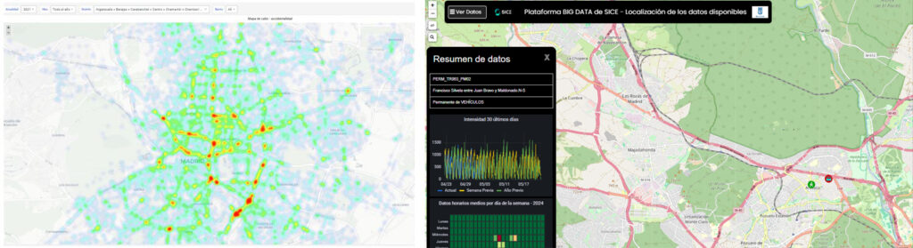
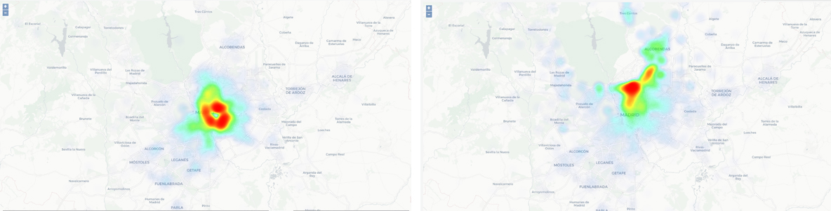
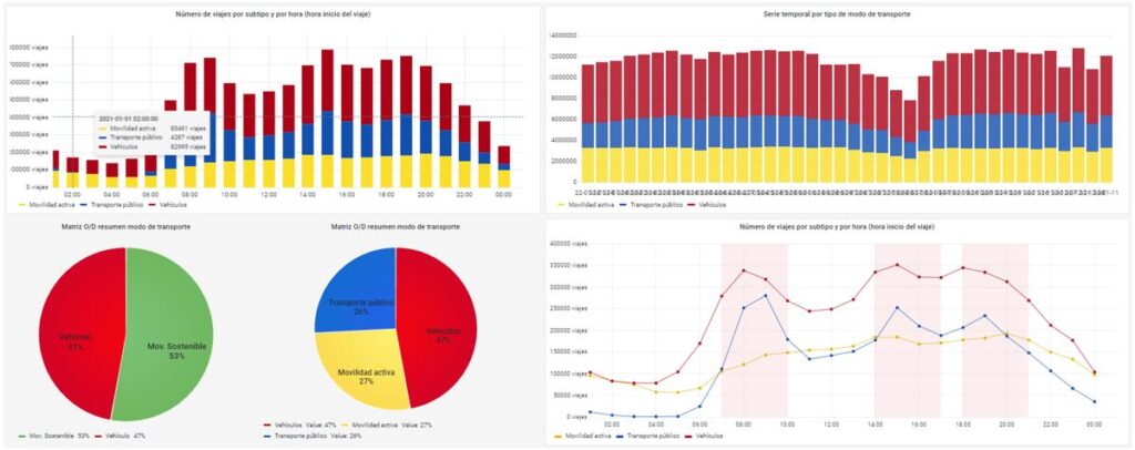
The Big Data platform SIDERA Analytics integrates different services of the City Council, such as data collected thanks to the City Council’s traffic technologies. For example, it offers within its GIS viewers relevant information such as the number of accidents recorded by the Municipal Police, which allows the areas of the city with the highest incidence of accidents to be analysed and measures to be taken to improve road safety:

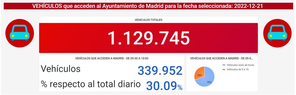
It also provides the number of vehicles entering and leaving Madrid each day: this data is very useful for understanding traffic in the city and making decisions accordingly.
These are just a few examples of how the use of the information collected through this platform provides a complete and detailed view of mobility in the city, resulting in better traffic planning and management and more efficient and sustainable mobility for all citizens.
One of the main components of the service contract for the collection and processing of real mobility data in the city of Madrid is the information obtained from mobile phone antennas. This source of information is particularly useful for collecting data on road traffic and private vehicle journeys, as most citizens carry a mobile device with them. The data are anonymised, guaranteeing the privacy of citizens and complying with the LOPD, as no personal information is collected, only mobility data.
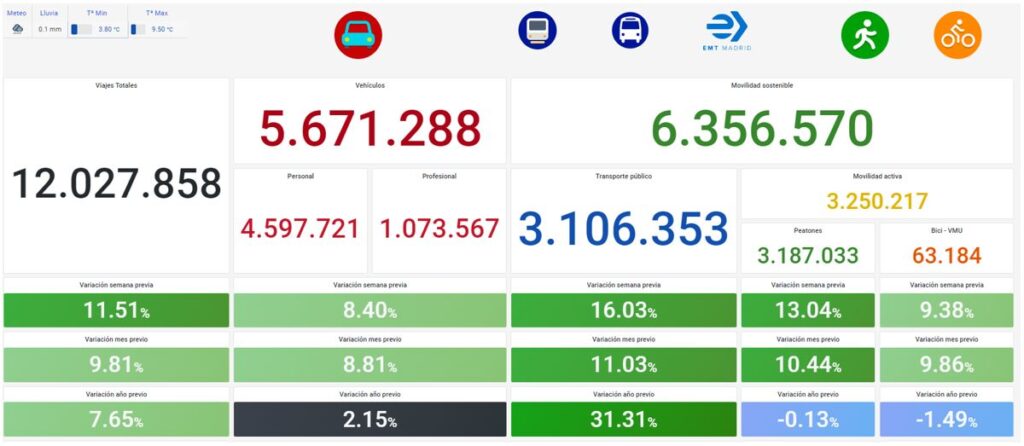
The information collected through mobile phone antennas makes it possible to know the number of vehicles circulating in a given neighbourhood or district, the journeys most used by citizens, or the main origin-destination flows between neighbourhoods, districts or municipalities with origin and destination in the city of Madrid. This makes it possible to break down the information collected by telephone and show it together with other sources of information such as data obtained from public transport operators (EMT or CRTM), among others.
Another important source of information is the EMT and CRTM databases. These two public entities are responsible for public transport in the city and the Autonomous Community of Madrid respectively, and therefore have detailed information on the number of passengers, frequency of services, routes and stops, among other aspects.
The integration of this information in the Big Data platform provides a global vision of mobility in the city, covering both road traffic and public transport. In this way, it is possible to identify the points of greatest demand for public transport and develop public policies that encourage its use, such as the creation of new transport lines, the expansion of the range of services on offer or improved accessibility.
The permanent gauging stations of the Madrid City Council are another important source of information for the service contract for the collection and processing of real mobility data in the city of Madrid. These stations are located in different parts of the city and allow measuring the number of vehicles circulating on a given street. These stations are divided into three types: motor vehicles, bicycles and pedestrians.
Recently, a new technology based on Artificial Intelligence has been developed, which allows to identify the type of user who is using mobility, i.e. whether it is a motor vehicle, a bicycle or a pedestrian. This technology is able to process the image captured by the cameras of the permanent gauging stations and, at the same time, store the trajectories of the identified vehicles.
It is important to note that although all these stations use cameras to collect information, they do not record video, but are able to process the images themselves and only store and transmit the data. In this way, the privacy of citizens is guaranteed, as no personal information is collected, only mobility data.
The AI-based image detection technology allows detailed information about mobility in the city, such as the type of vehicle or the trajectories followed by each vehicle. Thanks to this, it is possible to improve traffic planning and management.
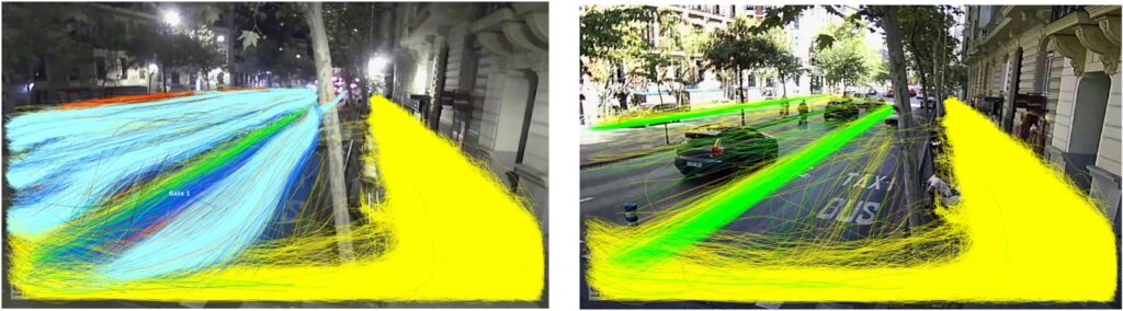
The information collected by these permanent gauging stations is particularly valuable for the analysis of bicycle and pedestrian mobility, as these users are often more difficult to measure and quantify than motor vehicles. Thanks to this new technology it is possible to obtain detailed information on the mobility of these users, which allows for better planning and management of public spaces, promoting safer and more accessible mobility for all citizens.
Mobility is a crucial issue in the urban planning and management of cities like Madrid. In order to make informed decisions on mobility policies, it is necessary to have accurate and up-to-date information on the mobility patterns of citizens. In this sense, this service contract of the Madrid City Council is an innovative initiative that uses cutting-edge technology to collect valuable information on citizens’ movements.